Travel planning app or website

Stow

Stow

Messages
84
Location
london
Vehicle
T6 Ocean 204
I'm currently planning my first long trip over four weeks through Europe, starting in Calais and heading down to Switzerland, Italy, France and home via the Santander ferry.

I've searched the forum and the wider internet but cannot find any solid and recurring recommendations for a way to map the route in advance so that it can be broken into daily drives and the route potentially uploaded or stored into Google Maps or my Garmin. I have explored My Maps by Google, but:
- it has limited functionality in terms of mileage and estimated time for travel per leg of journey
- it does not offer a range of routes (shortest/quickest etc) between two points.

I'm happy to be corrected on the above two limitations.

Question is: what websites or route planning applications do people use to plan longer trips across Europe (or even domestically), and do any of the planners tie in to calendar applications?

Thanks!
 
You have 4 weeks, over planning will mean you are perhaps under pressure each day to keep up with your plan. If your planning to use campsites OK, even then if your prepared to ‘free camp’ the odd day or so, go with the flow, roam and enjoy it.
 
I'm currently planning my first long trip over four weeks through Europe, starting in Calais and heading down to Switzerland, Italy, France and home via the Santander ferry.

I've searched the forum and the wider internet but cannot find any solid and recurring recommendations for a way to map the route in advance so that it can be broken into daily drives and the route potentially uploaded or stored into Google Maps or my Garmin. I have explored My Maps by Google, but:
- it has limited functionality in terms of mileage and estimated time for travel per leg of journey
- it does not offer a range of routes (shortest/quickest etc) between two points.

I'm happy to be corrected on the above two limitations.

Question is: what websites or route planning applications do people use to plan longer trips across Europe (or even domestically), and do any of the planners tie in to calendar applications?

Thanks!
If you have a Garmin, download Basecamp from Garmin, free software, that will do as you wish, using the maps on your Garmin. Set waypoints or destinations or campsites if you have the address, will give routes and distances etc.
Check it out.
Also will transfer data to your Garmin.
 
Thank you WelshGas. I try to avoid Garmin's software generally (as a cyclist it's really poor indeed) so I have ignored that application until now. I will investigate!

BerndRos, totally agree with you that over planning sets up pressure. At this stage I suppose I am looking more at the feasibility at what is possible, and putting in place some kind of skeleton of what the overall trip might look like and what is possible in terms of distances. I have 2 toddlers in the van so planning is, inevitably, something I cannot completely avoid.
 
I'm currently planning my first long trip over four weeks through Europe, starting in Calais and heading down to Switzerland, Italy, France and home via the Santander ferry.

I've searched the forum and the wider internet but cannot find any solid and recurring recommendations for a way to map the route in advance so that it can be broken into daily drives and the route potentially uploaded or stored into Google Maps or my Garmin. I have explored My Maps by Google, but:
- it has limited functionality in terms of mileage and estimated time for travel per leg of journey
- it does not offer a range of routes (shortest/quickest etc) between two points.

I'm happy to be corrected on the above two limitations.

Question is: what websites or route planning applications do people use to plan longer trips across Europe (or even domestically), and do any of the planners tie in to calendar applications?

Thanks!

We normaly us maps, google or some other navigation app. I often use via michelin on the desktop quite good and also with an cost indicator.
BTW sounds like a great plan and have fun planning!
 
Thank you WelshGas. I try to avoid Garmin's software generally (as a cyclist it's really poor indeed) so I have ignored that application until now. I will investigate!

BerndRos, totally agree with you that over planning sets up pressure. At this stage I suppose I am looking more at the feasibility at what is possible, and putting in place some kind of skeleton of what the overall trip might look like and what is possible in terms of distances. I have 2 toddlers in the van so planning is, inevitably, something I cannot completely avoid.
We have been pottering about Europe for 11+ months, continuously, with two boys initially ages 2 and 3.

We have major stops and minor stops. A major stop will be 4+ nights, and will be a place we particularly want to visit. On Google Maps we look at the route between two major stops, and break it down into legs of between 2h 30 and 4h, stopping for 1 or 2 nights between legs, extending if we like the venue.

For example, Calais to Florence is 15 hours. I'd be looking for four intermediate stops ~3h apart.
Calais to Reims 2h 43
Reims to Strasbourg 3h 30
Strasbourg to Andermatt 3h 12
Andermatt to Parma 3h 28
Parma to Florence 2h 17

Assuming you have places sorted at the start and at the major stop all you need do is look for sites at the intermediate stop area. To do this I generally use the ACSI Camping Card app, and if no luck there, the general ACSI app, and if still no joy, type "camping" into Google Maps over the area where I'd like to stay.

Nothing is inflexible except pre paid ferry passages.

Here is our planned route home:
- Krk
- 8 May Bled
- 12 May Bruneck (Dolomites) 3h 15 Corones
- 14 May Mustair (Dolomites) 3 hr Muglin
- 16 May Chur 2h 30 CampAu Chur
- 20 May Hopfgarten (Austria) 3h 15 Camping Reiterhof
- 22 May Inzell 4 3h 15
- 26 May Vienna 2h 45 Klosternuburg
- 28 May Terchova (Slovakia) 3h 30 Bela Nizne
- 1 June Prague 4h 30 Camp Matyas
- 3 June Swidnica 3h 30
- 9 June Berlin 3h 15 Eurocamp Spreewaldtor
- 11 June Bielefeld 4h CampingPark Bielefeld
- 13 June Cologne 2h 15 Knaus CampingPark Essen-Werden
- 15 June Home 6h 30

Already we have altered the first two intermediate stops.


Follow my blog: www.au-revoir.eu
 
Last edited:
We have been pottering about Europe for 11+ months, continuously, with two boys initially ages 2 and 3.

We have major stops and minor stops. A major stop will be 4+ nights, and will be a place we particularly want to visit. On Google Maps we look at the route between two major stops, and break it down into legs of between 2h 30 and 4h, stopping for 1 or 2 nights between legs, extending if we like the venue.

For example, Calais to Florence is 15 hours. I'd be looking for four intermediate stops ~3h apart.
Calais to Reims 2h 43
Reims to Strasbourg 3h 30
Strasbourg to Andermatt 3h 12
Andermatt to Parma 3h 28
Parma to Florence 2h 17

Assuming you have places sorted at the start and at the major stop all you need do is look for sites at the intermediate stop area. To do this I generally use the ACSI Camping Card app, and if no luck there, the general ACSI app, and if still no joy, type "camping" into Google Maps over the area where I'd like to stay.

Nothing is inflexible except pre paid ferry passages.

Here is our planned route home:
- Krk
- 8 May Bled
- 12 May Bruneck (Dolomites) 3h 15 Corones
- 14 May Mustair (Dolomites) 3 hr Muglin
- 16 May Chur 2h 30 CampAu Chur
- 20 May Hopfgarten (Austria) 3h 15 Camping Reiterhof
- 22 May Inzell 4 3h 15
- 26 May Vienna 2h 45 Klosternuburg
- 28 May Terchova (Slovakia) 3h 30 Bela Nizne
- 1 June Prague 4h 30 Camp Matyas
- 3 June Swidnica 3h 30
- 9 June Berlin 3h 15 Eurocamp Spreewaldtor
- 11 June Bielefeld 4h CampingPark Bielefeld
- 13 June Cologne 2h 15 Knaus CampingPark Essen-Werden
- 15 June Home 6h 30

Already we have altered the first two intermediate stops.


Follow my blog: www.au-revoir.eu

I think I may actually suffer from Holiday Blues when you guys get home - such is the escapism that your blog provides!


Sent from my iPad using Tapatalk
 
I've searched the forum and the wider internet but cannot find any solid and recurring recommendations for a way to map the route in advance so that it can be broken into daily drives and the route potentially uploaded or stored into Google Maps or my Garmin. I have explored My Maps by Google, but:
- it has limited functionality in terms of mileage and estimated time for travel per leg of journey
- it does not offer a range of routes (shortest/quickest etc) between two points.
!
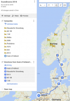
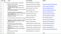
I usually do a combination of Google maps (saved) and a spreadsheet with campsites and stops listed examples;
upload_2018-5-11_8-6-4.png
Use layers for each leg if you like;

then some detail
upload_2018-5-11_8-7-55.png

you can add columns for driving time, milage etc.
 
Mrs VD is well into all the route planning stuff. But me, I love the serendipity of just rolling along until we feel like stopping, then looking for some kind of campsite. So we do it Mrs VD's way. Although we usually still only start looking for the night's stop once we're on the road for that day, or sometimes the night before.

That all works fine at this time of year on the Continent, when it's rare to find a campsite fully booked. BUT... what are folks' experiences in July and August? Which parts of Europe is it feasible to just 'plot and bash' during the high season? Last year we went down to the Alsace in late July and had little problem finding camping on spec. But what are others' experiences at that time of year?

Sorry for slight thread hijack BTW...
 
I have once or twice used Waze to plan future journeys... You can input dates on which you want to travel and what time you want to arrive etc, you can schedule several places and add them in. Obviously as you move around the times will adjust. It will then notify you when its time to leave. It's only a satnav and may not be quite perfect for what you want but it may work with a little prep before your trip.
 
Mrs VD is well into all the route planning stuff. But me, I love the serendipity of just rolling along until we feel like stopping, then looking for some kind of campsite. So we do it Mrs VD's way. Although we usually still only start looking for the night's stop once we're on the road for that day, or sometimes the night before.

That all works fine at this time of year on the Continent, when it's rare to find a campsite fully booked. BUT... what are folks' experiences in July and August? Which parts of Europe is it feasible to just 'plot and bash' during the high season? Last year we went down to the Alsace in late July and had little problem finding camping on spec. But what are others' experiences at that time of year?

Sorry for slight thread hijack BTW...
That's exactly what I've done for our European trip in July. I have driving time and distance for each leg on the spreadsheet too.
 

Similar threads

Art Vandelay
Replies
1
Views
1K
Californiaman
Californiaman
Eber123
Replies
22
Views
4K
Ting Tong
Ting Tong
GregW
Replies
136
Views
15K
Vagophile
V
Back
Top