Buy all your VW California Accessories at the Club Shop Visit Shop

Services on route (Discovery media pro)

M

myvanrodney

VIP Member
Messages
354
Location
UK
Vehicle
T6.1 Ocean 204
Would love to be able to easily find out what services are 'up ahead' while driving a route using the VW built in navigation. Scenario - driving along a motorway, would like to stop for a coffee... ad hoc, show me my options...

Whats the best way to display services (service stations) 'on-route' while navigating a route?

Dont want 'off route' recommendations, only services that are actually on the roads that make up my route.

If it cant be done on the VW navigation, any recomendations on how it might be done with carplay (any app)?

Thanks all!
Google maps used in satellite view. Siri voice search works reasonably well, Hey Siri, directions nearest cafe…..services…..etc will bring up Apple Maps with a list in distance and direction (hopefully).
 
Whats the best way to display services (service stations) 'on-route' while navigating a route?

Dont want 'off route' recommendations, only services that are actually on the roads that make up my route.

If it cant be done on the VW navigation, any recomendations on how it might be done with carplay (any app)?
This is something that the built-in Sat nav in the Audi we had before the California did really well. Always displayed all the upcoming service stations so you knew how far both the next one and the one after that was without having to touch the screen or do anything.

On the VW Sat nav, if you tap the arrow on the bottom left hand side of the screen, a side view opens displays a few random landmarks on the route. But I was never able to understand what it’s really displaying and what it’s supposed to be used for. That’s where you’d expect to see the upcoming service station but it doesn’t seem to work that way.

Neither Waze, nor Google Maps nor Apple Maps have a good solution for this. You need to explicitly search for a service station and then go through the suggestions to try and find out which one is actually on the route and which one takes you off route. That’s a lot of faff and it still won’t show you what you actually want to see: the list of upcoming service stations on the route.
While I did just write Waze @Mehdime is right - you do have to search while driving to get them to come up and them check the map to see which is on route. It works, of a fashion, but not ideal. TBH we avoid service stations unless we need to fuel up, which is easy enough without needing to use the map and if we need a break and cup of tea, well, we are in a Cali - we just stop where we like and make it there and then.
 
This is something that the built-in Sat nav in the Audi we had before the California did really well. Always displayed all the upcoming service stations so you knew how far both the next one and the one after that was without having to touch the screen or do anything.

On the VW Sat nav, if you tap the arrow on the bottom left hand side of the screen, a side view opens displays a few random landmarks on the route. But I was never able to understand what it’s really displaying and what it’s supposed to be used for. That’s where you’d expect to see the upcoming service station but it doesn’t seem to work that way.

Neither Waze, nor Google Maps nor Apple Maps have a good solution for this. You need to explicitly search for a service station and then go through the suggestions to try and find out which one is actually on the route and which one takes you off route. That’s a lot of faff and it still won’t show you what you actually want to see: the list of upcoming service stations on the route.
Exactly!
I had a range rover many years ago and it did this perfectly. I also have a very old garmin satnav for my motorbike and this does it too.

hmmmph!
 
I agree. We’ve tried this numerous times with not much success. Like others I’ve had systems on Audi and BMW that does exactly what you’re seeking. It seems such an obvious function, surely one of the mapping companies will include it at some point?
 
I agree. We’ve tried this numerous times with not much success. Like others I’ve had systems on Audi and BMW that does exactly what you’re seeking. It seems such an obvious function, surely one of the mapping companies will include it at some point?
isnt it!... i hope so
 
Just had a look at Apple Maps and Google. Apple is the same as Waze - you choose “add stop” and choose Petrol station. Then shows you the ones on route and then you choose where you want to add. You could do this at the start of a journey and choose the ones you want. Google looks closest to what you want - it is the same but the option is “show on route”, which is slightly more useful. No idea about the VW one though, never used it, find it the 7 Trials of Hercules just to get working.
 
Just had a look at Apple Maps and Google. Apple is the same as Waze - you choose “add stop” and choose Petrol station. Then shows you the ones on route and then you choose where you want to add. You could do this at the start of a journey and choose the ones you want. Google looks closest to what you want - it is the same but the option is “show on route”, which is slightly more useful. No idea about the VW one though, never used it, find it the 7 Trials of Hercules just to get working.
Me too, such a poor user interface when compared to other manufacturers. I will give google a look. Thanks for researching :thumb
 
Just had a look at Apple Maps and Google. Apple is the same as Waze - you choose “add stop” and choose Petrol station. Then shows you the ones on route and then you choose where you want to add. You could do this at the start of a journey and choose the ones you want. ............No idea about the VW one though, never used it,
That sounds mighty complicated when one press of the screen on the VW system gets you a list of eateries both en route & slightly off route. They all get listed with both time & distance implications, click on one for more info including phone number. I don't really know what more you want?
 
That sounds mighty complicated when one press of the screen on the VW system gets you a list of eateries both en route & slightly off route. They all get listed with both time & distance implications, click on one for more info including phone number. I don't really know what more you want?
lol... one press?

I suppose while driving in busy fast moving motorway traffic I find it difficult to determine what services are on-route, especially when a simple toilet stop is needed (I don't want really want to detour from my route just have a quick wee). Perhaps Ive been spoilt with this feature and got a bit 'stuck in my ways'
 
I really don't see how much simpler you want it?

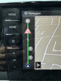
First photo map display showing eateries en-route

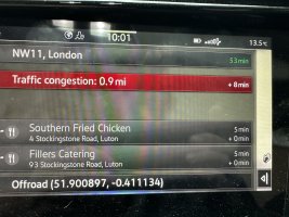
Second photo - what you see when pressing any of the Knife & Fork icons on previous screen - tells you how far away & the effect on your current route guidance. Thats my one press!

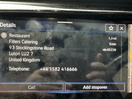
Third Photo - press on any of the displayed eateries to get further info.

IMG_4225.jpegIMG_4226.jpegIMG_4227.jpeg
 
I really don't see how much simpler you want it?

First photo map display showing eateries en-route

Second photo - what you see when pressing any of the Knife & Fork icons on previous screen - tells you how far away & the effect on your current route guidance. Thats my one press!

Third Photo - press on any of the displayed eateries to get further info.

View attachment 128808View attachment 128809View attachment 128810
wow! thanks for taking the time to send the photos..

this is my point -

"First photo map display showing eateries en-route"

they are not all 'on-route'
 
wow! thanks for taking the time to send the photos..

this is my point -

"First photo map display showing eateries en-route"

they are not all 'on-route'
Yes they are - both five minutes away and on the planned route.
 
That sounds mighty complicated when one press of the screen on the VW system gets you a list of eateries both en route & slightly off route. They all get listed with both time & distance implications, click on one for more info including phone number. I don't really know what more you want?
I don’t want either. Happy with Waze. Guess it’s all down to what the OP wants.
 
Yes they are - both five minutes away and on the planned route.
ah thats interesting... when Ive done it on the motorways its always wanted to take me off route and into a local town or city... I just want to know when the next motorway service station is
 
Sorry, but I find that those big signs on the Motorway or major A roads that detail where the next Services or Fuel stop are more than adequate to determine if my bladder can last to the next services or the one after.
 
Sorry, but I find that those big signs on the Motorway or major A roads that detail where the next Services or Fuel stop are more than adequate to determine if my bladder can last to the next services or the one after.
you don't have to apologise :thumb, but well done anyway
 
Just had a look at Apple Maps and Google. Apple is the same as Waze - you choose “add stop” and choose Petrol station. Then shows you the ones on route and then you choose where you want to add. You could do this at the start of a journey and choose the ones you want. Google looks closest to what you want - it is the same but the option is “show on route”, which is slightly more useful. No idea about the VW one though, never used it, find it the 7 Trials of Hercules just to get working.
Yes! google does it. Brilliant, thanks.
 
If you’re on main roads like motorways you don’t need any type of sat nav. Follow the road signs, pretty simple really.
 
If you’re on main roads like motorways you don’t need any type of sat nav. Follow the road signs, pretty simple really.
Thats very helpful, well done.
 
Back
Top