Buy all your VW California Accessories at the Club Shop Visit Shop

Trans-Pyrenees Trip late summer 2019

bvddobb

bvddobb

Top Poster
VIP Member
Messages
1,478
Location
Netherlands
Vehicle
T5 SE 174 4Motion
In less than two weeks we will take off for a trip through the Spanish Pyrenees, from the Mediterranean to the Atlantic Ocean. We have taken our inspiration for this trip the last two years from a variety of sources (see this link for an interactive version of our inspiration map):
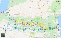
Pyreneeen-ideeen.jpg

  1. A trackbook we found on-line at vibraction.org. It describes a route from coast to coast, for 60% on off-road mountain tracks. The blue route and suggested campsites on the map.
  2. A like route we reconstructed form a travel blog on the German caliboard.de from user BIM. The purple route and suggested campsites on the map.
  3. Two little guides with one-day hikes in the Pyrenees. The yellow spots and suggested campsites on te map.
  4. A series of suggested campsites from various forums and blogs (the green ones on the map).

We will probably be 'flip-flopping' between these while en route.

Going there we plan to dash to about Lyon, and then leave the (in)famous 'Route du Soleil' and meander south on D-roads with a minimum of three digits through some national and regional nature parcs (the green route on the map):
  1. Parc du Pilat
  2. Parc des Monts d'Ardeche
  3. Parc des Cevennes
  4. Parc du Haut Languedoc
  5. Parc de la Narbonnaise et Méditerranée

Roughly a week going there, two weeks through the Pyrenees, and a week going back. We will try to share some impressions here!
 
We have done a couple of trans Pyrenees trips and the scenery is just amazing, be aware that some tracks get closed in the hot summer because of the risk of fire etc. also remember not to "Crop Dust" the walkers as that can also get some tracks closed if there are lots of hikers about.
 
I cycle camped that route in 2002.

During a full morning climbing a hill I found myself Anglicising names, for example, Col du Budincurutcheta became known in my mind as the Col of the Burning Crotch.

Absolutely stunning, and some day I’ve promised myself that I’ll do it from Cebere to Hendaye - unfortunately I’ve put on a full four stone in weight since 2002!

The ten day cycle route, which I did in nine, crosses 28 cols. The 100 hour route a mere 18.
 
Amarillo I need to bikepack that route! what time of year did you go?
 
Amarillo I need to bikepack that route! what time of year did you go?
July/August

There are two official routes for the Raid Pyrénéen (four if you count them each way). The road bike route which crosses 18 cols and is 720 km over 100 hrs and the tourist route which crosses 28 cols and is 790 km over 10 days.

For both routes, you can get a card stamped at various bars and hotels on the route which you can later exchange for a certificate and medal but we didn’t bother with that.

There are also companies which arrange accommodation and carry your luggage for you from hotel to hotel - we took a tent and didn’t bother with that either.
 
Last edited:
I cycle camped that route in 2002.
Ah, such spleen! Many, many years ago, when I was so much younger than today, I went from Atlantic to Mediterranean on foot, following the HRP trail, a high route roughly following the French/Spanish border crests (one foot in France, one in Spain, that idea), a lot higher up than the GR10 (French side) or GR11 (Spanish side). The HRP was not marked, like the GR's, it was described in a mountain guide by Georges Véron. Quite a walk: it took me 6 weeks! It was long before GPS, navigating with maps, compass, altimeter and binoculars!
 
Last edited:
Looks like a neat trip. Will do GR11 in the not too distant future.
 
We created a dedicated Instagram account for this trip: @bm_pyrenees
 
We have done some little bits of the route but inspired now to do the whole lot. Thanks for putting this on.
 
We have the .gpx files for you if you want...
That would be great, thank you.
I wouldnt worry too much about the bears. It is very rare for them to be seen and whilst they can cause a problem for the farmers it fairly unusual. We have had a house rhere for around fifteen years and walked many miles and never come across one. The popular hikes like the Odesa canyon get budy with people which the bears tend to shy away from.
 
fullsizeoutput_23b2.jpeg

Getting ready! We have moved the spare from underneath to the back, for easier acces. And we have decided to mount brackets for the sand plates, so they can be on the outside rather than in the back somewhere.

Of course, we hope to never have to use either! Back in Iceland we never had to use either spare or sand plates.
 
In the Pyrenees in our van right now, your trip sounds awesome :)
 
A68C8910-0157-4B5E-8D1E-3E3F1835E6FF.jpeg

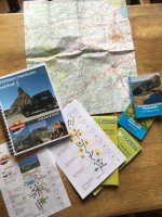
OK, Roadbook, 2019 update for Roadbook, maps, hiking guides: everything sorted!

Next step: upload all .gpx files to TomTom and topographic map apps, and off we go! (well...: still 4 days of work ahead... ;))
 
In less than two weeks we will take off for a trip through the Spanish Pyrenees, from the Mediterranean to the Atlantic Ocean. We have taken our inspiration for this trip the last two years from a variety of sources (see this link for an interactive version of our inspiration map):

View attachment 48375

  1. A trackbook we found on-line at vibraction.org. It describes a route from coast to coast, for 60% on off-road mountain tracks. The blue route and suggested campsites on the map.
  2. A like route we reconstructed form a travel blog on the German caliboard.de from user BIM. The purple route and suggested campsites on the map.
  3. Two little guides with one-day hikes in the Pyrenees. The yellow spots and suggested campsites on te map.
  4. A series of suggested campsites from various forums and blogs (the green ones on the map).

We will probably be 'flip-flopping' between these while en route.

Going there we plan to dash to about Lyon, and then leave the (in)famous 'Route du Soleil' and meander south on D-roads with a minimum of three digits through some national and regional nature parcs (the green route on the map):
  1. Parc du Pilat
  2. Parc des Monts d'Ardeche
  3. Parc des Cevennes
  4. Parc du Haut Languedoc
  5. Parc de la Narbonnaise et Méditerranée

Roughly a week going there, two weeks through the Pyrenees, and a week going back. We will try to share some impressions here!
Do you have solar panels fitted. Do you need them?
What tyres are you using?
Do you need engine/gearbox skid/bash plates?

This looks like my kind of trip.
 
Can’t resist showing off - I did this ten years ago whilst I lived in the Gers - but on foot! The HRP took me best part of 4 months (had a week off in the middle) but loved every single day.
 
That would be great, thank you.
I wouldnt worry too much about the bears. It is very rare for them to be seen and whilst they can cause a problem for the farmers it fairly unusual. We have had a house rhere for around fifteen years and walked many miles and never come across one. The popular hikes like the Odesa canyon get budy with people which the bears tend to shy away from.
 
Do you have solar panels fitted. Do you need them?
What tyres are you using?
Do you need engine/gearbox skid/bash plates?
Hi Anthony,

You can read more about our mods to make our Cali more 'sturdy' in this post here in the Off Road Section of this forum.

We do have solar panels fitted, yes. We do a lot of wild camping and the panels definitely make us more 'autark'. Usually, we are travellers, and don't stay in one place too long, but we have been in places standing still for 5 nights on row without any hook up while fridge, parking heater and interior lights were running when we needed them without issue. That's why we have them!

We use Michelin Latitude Cross AT's, 225/70/R16 103H, currently. Very happy with them! Used them since 2016 (our Iceland trip) for some 30.000 km's now. Still happy! Will renew them next summer, after 4 years and some 40.000 km's.

We do have bottom protection plates, yes. Do we need them this trip? Hope not! We have looked at some samples of the route on Google Earth and we do feel we are currently a bit 'over equipped' for this trip. It looks like a good set of AT's with a deflator/compressor combi to manage the tyre pressure according to terrain and some sensible steering will bring you a long way on this route, even in a 2WD. A little extra bottom clearance is always a big help.
 
Can’t resist showing off - I did this ten years ago whilst I lived in the Gers - but on foot! The HRP took me best part of 4 months (had a week off in the middle) but loved every single day.
Great stuff, José! Like we wrote above, we did the HRP in the early 80's, from Véron's original guide of 1981. It took us the best of 6 weeks, then.

To whom it may concern: we just learned there is a new e-book guide of the HRP (May 2019) available! "The HRP is not waymarked and borders on mountaineering at times, sticking as closely as possible to the main ridge (one foot in France, one in Spain). It stretches 750km from the Atlantic resort of Hendaye to Banyuls-sur-Mer on the Mediterranean, crossing the French-Spanish border many times on its traverse. The hike calls for experience, navigational competence and self-reliance, but offers rich rewards as you pass through some of the most stunning landscapes the region has to offer." A wonderful hike!
 
Back
Top